About Critical Mineral Assessments

The U.S. Geological Survey (USGS) has been mandated to conduct mineral resource assessments since 1879. Since then, certain minerals have been deemed “critical” given their purpose in the production and manufacture of various defense and high-technology products.

The Energy Act of 2020 defines a “critical mineral” as a non-fuel mineral or mineral material essential to the economic or national security of the U.S. that can be vulnerable to a supply chain disruption. USGS also characterizes critical minerals as serving an essential function in the manufacturing of a product, the absence of which would have significant consequences for the economy or national security.

Demand for critical mineral commodities has been on the rise given the proliferation of uses in consumer products such as electronic devices and electric vehicles. Research and assessment activities address the need for updated information on the nation's critical mineral resources within a global context.

The USGS has historically applied mineral resource assessments to major commodities (e.g., Au, Ag, Cu, Pb) as well as newly classified critical minerals (e.g., W, Zn, rare earth elements). Mineral resource assessment methods use information about identified domestic and global mineral deposits to estimate the potential for additional undiscovered deposits. Land management agencies, industry, and the public use this mineral resource information to help plan future resource development and weigh economic and environmental impacts.

For more information about USGS, visit www.usgs.gov.

Clarence King, first Director of the U.S. Geological Survey
Excert from 45th Congress Report - Geological Survey: 
                ...this officer shall have the direction of the Geological Survey, and the classification of the public lands 
                and examination of the Geological structure, mineral resources and products of the national domain...

“The least possible contribution to be made by the Federal Government should be a lucid, correct report of the production in each branch of mineral industry.”

Clarence King, Director
First Annual Report of the United States Geological Survey, 1880

(Source)

Current USGS Approach

The USGS receives requests for mineral resource assessments from Congress, the Bureau of Land Management, the U.S. Forest Service, and others. Collaborating with state geologic surveys and industry, using data from a variety of sources, conducting field work, employing mineral deposit models, and working in highly skilled teams, the USGS develops final assessment reports and data that range from defining prospective areas for a mineral commodity(s) to developing quantitative models of ranges of estimated amounts of undiscovered mineral resource(s) and potential economic value of those resources.

The USGS conducts both qualitative and quantitative assessments, dependent on a) customer needs and b) available geologic and geochemical data. Customers use both types of assessments for land-use planning and decision-making. Customers request qualitative assessments when they need a mineral potential map with tracts labeled as high, moderate, or low potential for select mineral resource(s). In other cases, customers require quantitative assessments to obtain probabilistic estimates of amounts of potential resources to support economic planning. Quantitative assessments require sufficient models of ore tonnage and grade from known deposits as analogs of potential resources in undiscovered deposits. When tonnage and grade models are not available, the USGS can only provide qualitative assessments.

The USGS measures the success of its high-quality mineral assessment efforts by report citations and references and new sources of critical materials identified.

The image below shows the current USGS mineral resource assessment workflow from receipt of need, to publication and release to customers. The workflow includes creation of both qualitative and quantitative assessments.
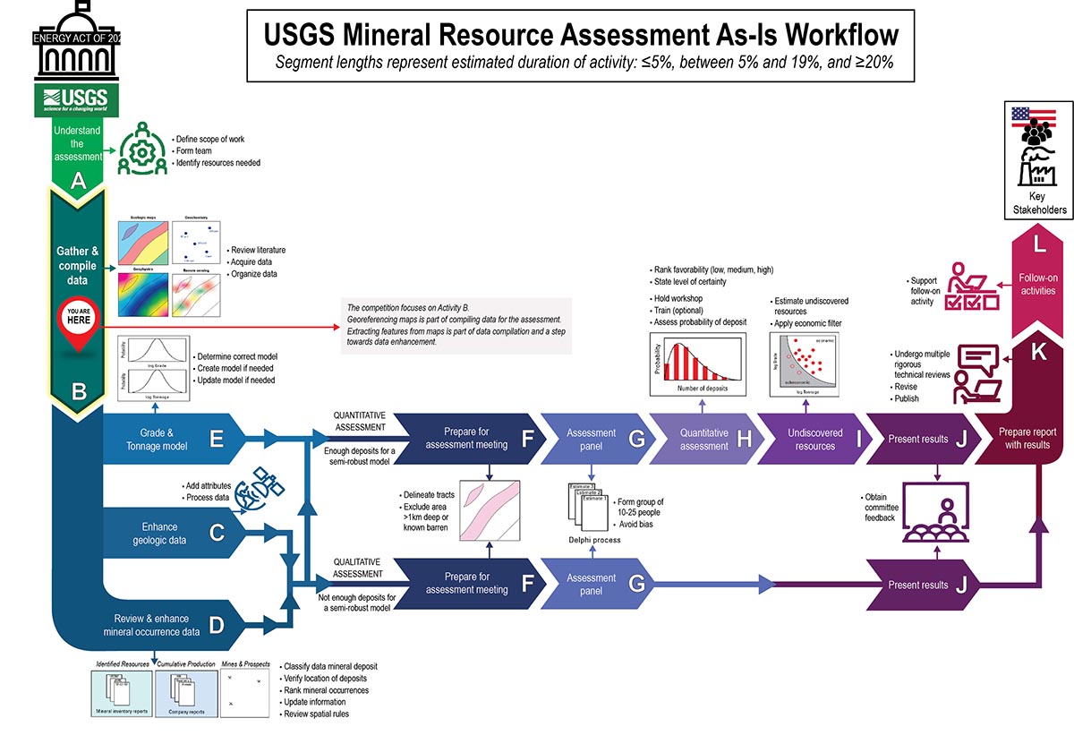
Baseline geologic, geophysical, and geochemical data are essential for both qualitative and quantitative mineral assessments because these data help USGS geoscientists identify geologic environments where minerals of interest are most likely to be concentrated. Current methodology requires significant manual efforts to 1) locate relevant data (maps and associated data), 2) extract those datasets, and 3) place those maps/data in spatial context) (steps A-D in the above figure). USGS can only complete quantitative assessments if sufficient data is available for the grade-tonnage model (E in the above figure). Capturing the location of potentially permissive geology and attributing those units to better identify truly permissive geology are currently very time-consuming efforts, and thus are part of several processes that could benefit from automation.

You are now leaving the website that is under the control and management of DARPA. The appearance of hyperlinks does not constitute endorsement by DARPA of non-U.S. Government sites or the information, products, or services contained therein. Although DARPA may or may not use these sites as additional distribution channels for Department of Defense information, it does not exercise editorial control over all of the information that you may find at these locations. Such links are provided consistent with the stated purpose of this website.


After reading this message, click  to continue immediately.

Go Back